Who Mapped the Ancient World - Music Banter Music Banter

Go Back   Music Banter > Community Center > The Lounge > Current Events, Philosophy, & Religion
Register Blogging Today's Posts
Welcome to Music Banter Forum! Make sure to register - it's free and very quick! You have to register before you can post and participate in our discussions with over 70,000 other registered members. After you create your free account, you will be able to customize many options, you will have the full access to over 1,100,000 posts.

Reply
 
Thread Tools Display Modes
Old 10-13-2013, 01:07 PM   #1 (permalink)
Account Disabled
 
Join Date: Jun 2013
Posts: 899
Default Who Mapped the Ancient World

There hasn't been a thread about this that I can find so I may as well start one. THIS IS NOT AN ANCIENT ASTRONAUT THREAD!!! There has been an argument among scholars for some time now about the voyage of Magellan's from 1519 to 1522 where he discovered the straits that the tip of South America now named after him--the Straits of Magellan. The problem is, the map he used to get there already had the straits on them! But even stranger, WHO made this map and how did they know about the Straits? No one is sure today exactly what map Magellan used but it is generally agreed to be a form of the Piri Reis map:


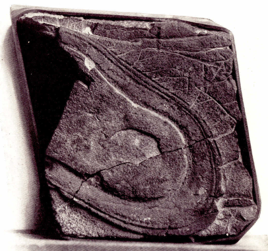
Piri Reis was a Turkish general whose map is a copy of a copy of a copy ad infinitum. On the left it shows an area of Argentina called Patagonia and on the right we part of Africa and Spain. At the bottom we see a blank area with a jagged sort of border. That's pack ice. The indented area by the ships is the entrance into the straits. Remarkably, we see what appears to be part of Antarctica (not officially discovered until 1819) and a group of islands that appear to be, for all the world, the South Shetland Islands off the coast of Antarctica.

A modern map of Patagonia:


Comparing it to Piri Reis, we see we see that bit of land jutting out from Patagonia and the entrance to the straits under that. Now, it's much further south than what Piri Reis shows but, again, we're dealing with a map that was a copy of many previous copies so things are out of scale. Africa and Spain are also grossly out of scale with South America. Some try to say that the hump of land is not Patagonia but the entire hump of South America formed mostly by Brazil!! This would make the map so grossly out of scale as to be worthless. Magellan could never have found the straits if this were the case. Furthermore, the compass circle off the coast of Patagonia shown on Piri Reis sits just about where the Falkland Islands sit and it would make sense that this expedition--whoever they were--would have used it as a navigational aid and to take some measurements. The Falklands are shown on the modern map for comparison.

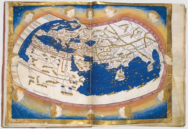
So the question is, who made this map and when? Gavin Menzies insists it was the Chinese. He's taken a lot of heat from the scientific community but that same community offer no answers at all. The Chinese or Koreans definitely did undertake a global mapping expedition because of the Kangnido map that dates from no later than 1402, well before Columbus. It is being housed and preserved in Japan:


This map shows Korea, Japan, China, India, Central Asia, Mongolia, Saudi Arabia, Africa and Europe in remarkable detail for its time. Somebody had to voyage at some point to produce a map like this.

In the early days of exploration, no one was even sure what was beyond the equator. To make up for it, they invented a "counterland"--a fictional land to take up the bottom space on the map so it didn't look so barren. It was purely decorative and did not resemble Antarctica in any way and was not meant to since no one even knew there was an Antarctica then:


Or did they? The Oronteus Finaeus map of 1531 tells us that someone knew about it. Dividing the map in half, the right half depicts Antarctica with shocking accuracy. The tips of South America and Africa (with Madagascar) and clearly visible and the land mass in question is given its own projection so this is clearly NOT a mere counterland.


The cartographer, Martin Waldseemuller, drew a map showing the isthmus of Panama in 1507. The map shown below is Waldseemuller's map. In the small inset at the top right center, one can see the isthmus clearly drawn. The problem is it wouldn't be officially discovered until 1513 by Balboa, six years after Waldseemuller drew it:


I don't want to talk just about maps. There's a lot of strange stuff we have found about the ancient world but this post will kick it off.

Last edited by Lord Larehip; 10-13-2013 at 07:02 PM.
Lord Larehip is offline   Reply With Quote
Old 10-13-2013, 01:25 PM   #2 (permalink)
David Hasselhoff
 
Paul Smeenus's Avatar
 
Join Date: Feb 2013
Location: Back in Portland, OR
Posts: 3,680
Default

This is the type of topic you write very well, kudos
__________________
Quote:
Originally Posted by grindy View Post
Basically you're David Hasselhoff.
Gentle Giant Catalog Review

The entire Ditty Bops catalog reviewed
Paul Smeenus is offline   Reply With Quote
Old 10-13-2013, 01:57 PM   #3 (permalink)
air quote
 
Engine's Avatar
 
Join Date: Jun 2009
Location: pollen & mold
Posts: 3,108
Default

Those are some beautiful maps.
__________________
Like an arrow,
I was only passing through.
Engine is offline   Reply With Quote
Old 10-13-2013, 02:43 PM   #4 (permalink)
Music Addict
 
crukster's Avatar
 
Join Date: Dec 2010
Posts: 181
Default

ohoho not one person, many people with cartographers and compass
crukster is offline   Reply With Quote
Old 10-13-2013, 09:21 PM   #5 (permalink)
Account Disabled
 
Join Date: Jun 2013
Posts: 899
Default

Maps were extremely important back then. The various nations of Europe were competing for routes to India, China, Japan, the Spice Islands, etc. Spices were an EXTREMELY lucrative business. Some spices were literally worth more than gold ounce for ounce and pound for pound. The Dutch East India Company, the world's first international corporation, had many detailed maps of the world and kept them VERY secret. Accurate maps were highly sought and prized. Just a single accurate map could make a nation rich beyond its citizens wildest dreams. Maps caused wars.

The thing is, the real power behind nations were the cartographers. Without them, ships had nowhere to sail nor had any way to get back. Kings and govts had to make sure cartographers lived very comfortably because it one get fed up and fled to a rival nation, he took his knowledge with him. Govts must have spent a lot of time trying to entice cartographers from rival nations to defect to them with all sorts of outlandish promises.

But cartographers must have been, in themselves, a secret society. People are always jawing about Knights Templars and Freemasons and the Illuminati when the most secret society of all is under our very noses--the real kingmakers and deal-breakers--the cartographers. They had to have had a long line of succession and many older--far older--maps to use as source material. How else do we explain Waldseemuller's map? He could not have gotten his data from contemporary sailors. Here is a Spanish map from 1544, some 37 years after Waldseemuller's map based entirely on contemporary data:


Not very impressive. So we can surmise then that cartographers used old maps--mysteriously accurate--and added new info when it seemed to further refine their knowledge. The older maps were handed down or bequeathed to them by their teachers in the craft. Moreover, it seems likely that cartographers of even rival nations may have secretly shared maps and kept the most sensitive data completely secret even from their kings and queens. Sworn to secrecy among themselves, they revealed only what their secret society told them. To disregard that was to risk being expelled and this was a proud profession and none dared risk such a dishonor. Besides who knows what agents or other members this society had that could make someone die accidentally if they ordered it?

So we can surmise that Waldseemuller made a map that showed the isthmus of Panama six years before its discovery because he was allowed to or perhaps he did it without realizing the goof (pretending it was a goof). His subsequent maps did not show the isthmus and so it was either an agreed on one-time thing or he was made aware of his error by the society and told not to do it again. Scholars have tried to maintain that Waldseemuller was just guessing and got it right by coincidence but that is simply not very convincing.

There appears to have been a "secret" knowledge about the globe and the other stars and planets but where it came from is anyone's guess. For example, in Swift's Gulliver's Travels he wrote of Mars as having two moons, gave surprisingly accurate distance of each moon from the planet and added that one moon orbited twice in a Martian day--all of which is correct but written 150 years before anyone supposedly knew that Mars even had moons at all. That Swift could have guessed this is beyond serious consideration. He got the knowledge from some source lost to us today but what was it and where is it now?
Lord Larehip is offline   Reply With Quote
Old 10-13-2013, 09:21 PM   #6 (permalink)
Account Disabled
 
Join Date: Jun 2013
Posts: 899
Default

Are there esoteric manuscripts from these times that we can point to? Yes, one of the most mysterious is the Voynich Manuscript. It was written probably in Italy in the early 15th century by an unknown author in an unknown language or writing system. No one has yet deciphered it although a great many have tried. It is written in dozens of strange glyphs of which about 25 are repeated many times throughout the text which is about 170,000 glyphs long. The rest of the glyphs appear only once or twice. This makes the task of deciphering the writing exceedingly difficult. A page from the Voynich Manuscript:


The manuscript is also full of colored illustrations. Whether the author is also the artist is unknown:


This one appears to be a galaxy.


This was obviously a document of a secret society. Some attribute it to Da Vinci but this is not convincing. Da Vinci never wrote in any such code in anything else and the artwork certainly does not compare to Da Vinci's talent. Whoever the author was, he was educated and either wealthy or patronized by someone of wealth. The work had to be produced for some kind of audience but obviously that audience would have to know how to read the glyphs so it was not meant for anyone outside a certain circle.

What society was this and who belonged to it is anyone's guess. What knowledge is contained in the codex and where it came from is also unknown. It seems to me however that this is a very important find and deciphering it may tell us a lot about our past.

Last edited by Lord Larehip; 10-13-2013 at 10:55 PM.
Lord Larehip is offline   Reply With Quote
Old 10-16-2013, 05:37 AM   #7 (permalink)
Shoo Thoughts
 
Mr. Charlie's Avatar
 
Join Date: Oct 2013
Location: These Mountains
Posts: 2,308
Default

Excellent thread. I love maps, old and new, they always kindle a sense of journey and adventure.
Mr. Charlie is offline   Reply With Quote
Old 10-24-2013, 09:33 PM   #8 (permalink)
Account Disabled
 
Join Date: Jun 2013
Posts: 899
Default


Fossilized shoeprints? They were discovered near Antelope Springs, Utah in June 1968 by an amateur fossil expert named William J. Meister. Since that time, numerous other shoe prints and footprints have been found in the area including those of children. I gave the age as 2-5 million years as the period of time it takes for prints in mud to turn into solid rock. However, the Utah prints are unique in that at least two trilobites were found crushed and embedded in the prints. Trilobites first appeared in the Early Cambrian period starting about 540 million years ago. They disappeared in the Permian period about 250 million years ago.

That makes these shoe prints about 250 million years old. It seems too incredible to be true. Science in general rejects this fossil evidence saying that the prints are simulacra—something naturally formed but insubstantial that resembles something artificial or man-made. And yet what are the odds that nature could haphazardly form two simulacra in close proximity that just happen to resemble a left and right shoe both in shape and size? What about the other prints that have since been discovered in the area? All simulacra apparently. The fossil-hunters had the prints examined by various shoe manufacturers who are very frequently consulted by police to identify shoe prints left at crime scenes and whose testimony in court can convict or acquit a suspect. Without exception, they identified the prints as being shoes. The heels of the shoes are easily discernible. Detailed analysis detects stitching all around the soles (pointing to shoes not sandals or moccasins—not that either of those would be any less astonishing) and the front of the prints depict exactly the type of depression one finds when someone is walking and pushing off with the toes. Chemist Melvin Cook from the University of Utah concurs that these are human footprints.


200 million + year-old shoeprint discovered in Nevada.


This shoeprint was discovered in Nevada in solid granite and dated to at least 15 million years.

And you can find a million creationist websites claiming this proves the earth is only thousands of years old and a million more science websites swearing up and down that this "bad archaeology."

What other bad archaeology can we unearth? How about the Klerksdorp Sphere?


The sphere was found in a South African Precambrian mineral deposit. It is actually rather small with three grooves. It certainly looks artificial but has been dated at 2.8 billion years. Yes, billion. Artificial or natural? Before you answer, it’s made of metal. Maybe it was mis-dated.


Thousands of the little metal parts were found in the Urals in the 1990s. Some are so small they are literally microscopic (1/10,000 of an inch). They were found in sediment 3 to 40 feet deep by gold miners. This would make them anywhere from 20,000 to 100,000 years old.
Lord Larehip is offline   Reply With Quote
Old 10-24-2013, 10:57 PM   #9 (permalink)
carpe musicam
 
Neapolitan's Avatar
 
Join Date: Apr 2009
Location: Les Barricades Mystérieuses
Posts: 7,710
Default

Quote:
Originally Posted by Lord Larehip View Post

Or did they? The Oronteus Finaeus map of 1531 tells us that someone knew about it. Dividing the map in half, the right half depicts Antarctica with shocking accuracy. The tips of South America and Africa (with Madagascar) and clearly visible and the land mass in question is given its own projection so this is clearly NOT a mere counterland.

That map reminds me of the Mandelbrot set, and the way they represented Earth on the map looks like the main cardioid.
__________________
Quote:
Originally Posted by mord View Post
Actually, I like you a lot, Nea. That's why I treat you like ****. It's the MB way.

"it counts in our hearts" ?ºº?
“I have nothing to offer anybody, except my own confusion.” Jack Kerouac.
“If one listens to the wrong kind of music, he will become the wrong kind of person.” Aristotle.
"If you tried to give Rock and Roll another name, you might call it 'Chuck Berry'." John Lennon
"I look for ambiguity when I'm writing because life is ambiguous." Keith Richards
Neapolitan is offline   Reply With Quote
Old 10-25-2013, 10:02 AM   #10 (permalink)
Account Disabled
 
Join Date: Jun 2013
Posts: 899
Default

Even stranger, is that Mandelbrot developed his concept of fractals in an effort to mathematically explain irregular topographic regions and irregular coastlines. The first practical use for fractals came from Hollywood when an FX guru wanted to create 3d computerized landscapes for movies. Although this is old hat now, it was brand new at the time. What enabled him to do it was when he read Mandelbrot's book on fractals. He began developing a program that would generate fractal algorithms so that he could create any landscape he envisioned within a few minutes. We can do this routinely now but it was fractals that enabled it. Fractals and land masses seem to go together. So you have to wonder if Mandelbrot rediscovered rather than discovered this knowledge and are subtle clues worked into these maps?
Lord Larehip is offline   Reply With Quote
Reply


Similar Threads


© 2003-2024 Advameg, Inc.